


Jeanviet 4 years ago
Tu veux créer un zoom vidéo depuis l'espace (ou le ciel) sur ta maison ou ton appartement. Je te montre comment faire (sans ...
GOJAMBAR 3 years ago
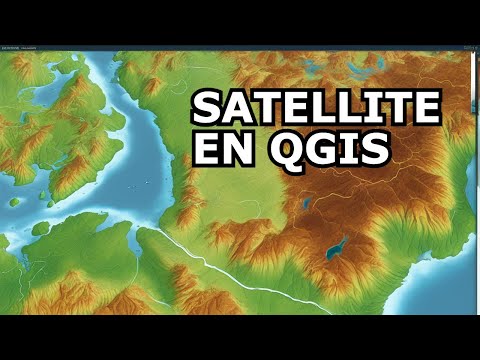
Dans cette video vous apprendrez comment obtenir des #fonds de carte google & Satellite à l'intérieur de #Qgis. Un moyen ...

Saif Eddine DERRADJI - GIS and RS 5 years ago
GOOGLE EARTH PRO: enregistrement d'une image satellitaire.

legeolog A year ago
googleearth #tutorial.
Geospatial World 8 years ago
The tech giant has added more details and better colours to the apps. Both the applications will feature the data captured by ...

RS & GIS 8 months ago
High-resolution imagery can be used for many purposes, including digital and print maps, backgrounds for drawings, ...

Login Giants 2 years ago
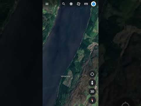
How To Change The Year On Google Earth | View Satellite Image Of Any Date In Google Earth Mobile App In this tutorial, we will ...

GIS Madras 4 years ago
This video provides step by step information to Download Very High Resolution Google Earth Pro Images for Free. Related Video: ...

Thecoolguy110 2 days ago

Geodatascience A year ago
veillez nous nous contacter pour avoir les ressources , si vous ne disposez pas de logiciel Google earth pour télécharger l'image.

Balkan Architect 6 years ago
Complete Revit Courses: https://balkanarchitect.com/ Project files: https://www.patreon.com/balkanarchitect Google Map ...

AsktheTechies 13 years ago
http://AsktheTechies.com D.Lee shows how to overlay an image onto Google Maps using Google Earth. For an example, he ...

Parlons de Cartographie A year ago
Dans cette vidéo, découvrez comment télécharger des images de haute résolution sur Google Earth et les enregistrer.

GIS & RS Solution A year ago
Welcome to @GISRSSolution. This video is about how you can add Google map, Satellite map, google earth map in ArcGIS.

Formation SIG, MINES, STATISTIQUES FSMS 2 years ago
Dans cette vidéo, vous allez apprendre à Géoréférencé une carte raster dans ArcGIS en utilisant google Earth pro.

Formation SIG, MINES, STATISTIQUES FSMS A year ago
Dans cette vidéo, vous allez apprendre comment télécharger une image dans le logiciel google Earth pro pour pouvoir l'utiliser ...

GeoDelta Labs 4 years ago
In this video, you will learn how to add Google Maps, Google Satellite and Google Satellite Hybrid as base layers in QGIS3. This is ...

UMFK Forestry 4 years ago
DELETE the space after "https" in the link here (the URL was being abbreviated and made useless before) https ...

Geomatique pourtous 2 years ago

GIS & RS Solution 2 years ago
In this video, you will learn how to download high resolution historical satellite images using google earth.

Jess Zimmerman 2 years ago
This video shows several ways to get Google Earth images into QGIS, with a focus on using base maps to create high-resolution ...

GIS & RS Solution 8 months ago
Hello everyone, welcome to a brand new video on GIS & RS Solution YouTube channel. Today, I am going to show you an ...

RS & GIS A year ago
This video is about adding Google Earth images to ArcGIS software. To be able to import the Google Earth images to ArcMap ...

Bendobrown 3 years ago
This tutorial is part 9 of the OSINT At Home series. It covers a common question that I get asked a lot, which is where I am getting ...

Formateur Hermann KONAN 2 years ago
Dans cette vidéo, vous allez apprendre Importer une image google earth comme fond de carte pour situer vos travaux (levé topo, ...

Geo RGB 3 years ago
To learn more about Geo RGB, visit us at: https://giscourse.online Visit us in the facebook page at: ...

Andy's Guides 5 months ago
How to Change Year on Google Earth Satellite View (full 2024 guide) In today's video we cover how to change year on google ...

LAJ CAD-Forum 2 years ago

Worldy_Guy 2M A year ago
Cartoon Doraemon on Google Maps and Google Earth #shorts #googleearth #googlemaps #world #travel #memes #worldmap ...

Guiding Tech 3 years ago
If you're having trouble visualizing a route or place, google maps can helpfully give you a general bird's eye view of what it looks ...
Tech Star A year ago
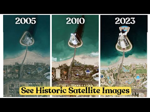
How To See Historic Satellite Images Of Any Location | Google Earth Pro Download Google Earth Pro: ...

EarthFindings 4 years ago
Who wants to live here? Google Earth #Shorts #googleearth #maps #earth #home #travel #viral #island #weird #loneisland ...

Formation SIG, MINES, STATISTIQUES FSMS 4 years ago
Comment utiliser google earth pour géoréférencer une carte ou image dans Qgis. Prélever des coordonnées de points de ...

Map Point 7 days ago
Seven-spot ladybird In Real Found On Google Earth And Google Map #shorts #mappoint #mappoint @mappoint0 ...

Earth secret 377 A year ago
Harry Potter movie location found on google map and google earth #map #earth #earthsecret377 #google.

ahmed dairi 4 years ago

Made 4 Geek 4 years ago
How to download high resolution satellite image from google earth, and how to georeference google earth image. Link to ...

EarthFindings 4 years ago
Titanic on Google Earth? #Shorts #googleearth #maps #earth #titanic #travel #viral #sea #weird #creepy.

Explore RS & GIS Tutorials 2 years ago
In this video I will show you step by step procedure on How to download high resolution satellite image from google earth pro then ...

Geocarto 2 years ago
This video will show you how to overlay an image in Google Earth Pro. This operation is very handy if you want to visualize a map ...

UTMLibrary 12 years ago
Cette vidéo vous montrera comment ajouter une superposition d'image dans Google Earth. Nous allons vous montrer comment ...
MYstisk 3 years ago
Please subscibe if you like the videos. https://youtube.com/channel/UCsBmkYt1ZtPlfLyxIRP8zCA Keyword Research: scary ...

Doc Seven 2 years ago
Ma boutique: https://shop.docseven.fr/ Mes réseaux sociaux: https://linktr.ee/DocSeven 77 Faits INCROYABLES sur les DÉSERTS ...
Google Earth Street View 2 years ago

Home Made School 7 years ago
Comment changer l'unité d'affichage sur Google Earth? ------------------ Liens utiles : - Facebook ...

Parlons de Cartographie A year ago
Vous êtes passionné de géographie et vous souhaitez apprendre à créer des cartes fascinantes avec Google Earth ?

KnowledgeBase 2 years ago
Travel back in time with Google Maps! This video explains how you can see old Google Maps street views and compare them to ...

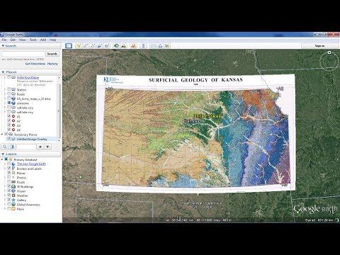
Géologie 95 4 years ago
Made 4 Geek 7 years ago
Georeferencing maps in Google Earth.

SITESH SINGH SOLANKI 3 years ago
sitesh singh Solanki. shivaji forming maharshtra. shivaji farming maharastra. new status white horse on map white horse cought ...